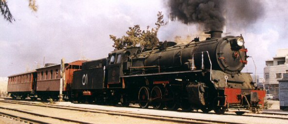
The
Hejaz Railway
Geography of the entire railway line
The railway line originally began in
Damascus-Kadem, but was extended in 1911 for another 5 kilometers to a
terminal station in the city center of Damascus. The line leads from the
present capitol of the Arab state Syria in a southerly direction to
Transjordan, which connects to the plain of Damascus.
In essence, the railway line follows the old
caravan route of traders and pilgrims between Damascus and Medina. This
had the special advantage that existing water resources could be used.
Given the steam locomotives were in operation at the time, water
availability was a prime necessity.
Southward,
along the Hauran mountains to the left side, the line gently drops away,
finally approaching the city of Dera’a. After Dera’a the line rises
again up to 1000 meters above sea level in Ma'an, falling in altitude
only in a few places such as Khirbet, Semra and Dammam. Up to Ma’an and
onward to the border of Saudi Arabia, the surface structure consists
mainly of rocky desert, interrupted at times by a few dry valleys
(wadis).
From the boundary, up to the city of Tabuk, the
landscape turns into a sandy desert. Behind Tabuk, at the end of a
plateau, and after crossing the first mountain ranges of the Hejaz, the
descent begins to the Wadi Akhdar and passes the second and last tunnel
on the line.
Leaving the tunnel, the line winds in a narrow
valley to the station of Akhdar and then follows the Wadi over many
miles to the station El Mu'assam. Here, the Wadi is very wide. After
crossing the wadi, the line rises again to its highest point near El
Muteli at about 1200 meters above sea level. The route runs along a
plateau with bizarre rock formations of sandstone and then descends into
the fertile Wadi El Ula. Prior to El Ula station the line reaches the
station at Medain Saleh, the ancient Nabatean city of tombs.
After passing Al Ula station, the train runs
quite straight until it enters Zumrud wadi, where it follows to a small
pass which then leads into a new wadi. From here the landscape changes:
the mountains are rugged, because they have a volcanic origin and
therefore are of solid nature consisting of lava and granite. Especially
in the evening light here, the visitor will be surprised with a play of
many colors, because the mountains are traversed by veins of minerals
that are oxidized at the surface, and thus offer the varied colors of
oxidation.
The wadis become increasingly narrow and there
are many small passes to traverse in between the wadis. This topography
continues until after the station Muderij. Before reaching Hedia
station, a wide wadi is straddled by the longest bridge of the entire
line.
After Hedia and until Dscheda a huge basin
surrounds the remnants of a gigantic volcano.
Behind Dscheda the line crosses a small pass and
descends into the long Wadi Al Buwair and remains at almost the same
level until after the station Hafireh. Here, a relatively high pass has
to be crossed, which has its highest point at the station Muteid.
Passing Muteid, the line descends again into a
new wadi that leads directly to its destination: the holy city of
Medina.


